

Case description
Combine is the founder of the app Geoguide. An app which is based on a map and information about parks, routes and attractions. They work on a module-based design where different modules are added to their basic product in order to target other businesses and end-users. The goal is to downstream the configuration of the product to the organization, so they can deploy their unique map based experience without contacting developers or other Combine Staff.
What Combine want from us, is inspiration for more modules, features and functions for a broader target audience than nature parks. Our task is to explore opportunities for cities as target audience.
Members of the team
- Agnete Egebjerg (Experience Design)
- Andreas Engell Refstrup Sørensen (Interactive Digital Media)
- Ana-Maria Pashova (Entrepreneurial Engineering)
- Aashwin Shrivastava (Entrepreneurial Engineering)
- Julia Jørgensen (Experience Design)
- Alireza Amini (Interactive Digital Media)
Concept video
This app shows cities in another way, different than what tourists are used to. It focuses on authenticity, hidden spots and it invites both visitors and locals to go on a treasure hunt in destinations all over the world.
The app makes it possible to tailor a personal profile, but not by the categories
that are most common in other city guide apps. In this app the user tailors a profile by choosing between means of transportation, type of tourist, interests and duration of stay.
The app will then show the user the routes to all the hidden gems in the city while taking the tailored profile in considerations when planning the routes. In addition to that, by exploring new locations, the user could gain bonus points and get discounts for local coffee places and restaurants. This could help both the local owners to attract new clients and the tourist to explore the authentic taste of the city.
The Design Process
First meeting with case partner
On the first day, we were put into groups and had the case introduced to us. After that, we had a brief discussion of our initial thoughts and prepared some questions. Our case partner, Combine, then came and presented the case in more detail, while we were asking questions. After we got the basic requirements they had for their product, we began to brainstorm again, and discuss which ideas we should proceed with. From this meeting, we learned that we had more creative freedom than we believed at first.
Fieldwork
To collect more data, we decided to split up our fieldwork into 3 different groups. One group went to Thy National Park to discuss the product with one of the project leaders, Bo Immersen. From this interview, we gained the perspective of a buyer of the product. Bo expressed a general level of satisfaction with the end product. He said, that it gives a nice overview, and tells you what you are missing out on. He was not satisfied with CMS, however. It was complex and had smaller issues here or there. He found that the biggest issue was generating the content since it is very time-consuming. He would wish for Combine to take a bigger part in creating and maintaining the app.
The two other groups made semi-structured interviews with people in the street in both Aarhus and Aalborg; asking them what they would want from this kind of app. The group in Aalborg interviewed both locals and tourists, whereas the group in Aarhus mainly interviewed tourists. Afterward, the group in Aarhus went to Visit Aarhus and interviewed them in regard to their app. In addition to the semi-structured interviews we also made an online survey to get a wider perspective on the use of city guides. From this data we got a lot of insights from the end-user on how to form the strategy of our concept.
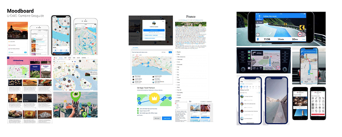
In addition to our fieldwork we made a research on competitors on the market. From here we made a moodboard of nice features and a mindmap of features a cityguide can contain.
Ideation
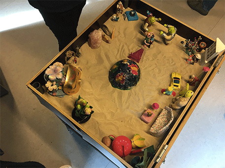
Sandbox
In order to ease the ideation process, we used several tools that helped us out. For visualizing the whole idea, we used the Sandbox method. We formed an abstract representation of our observations related to the concept. Afterwards, by describing and discussing the created image, we managed to sort out the general directions and ideas and we made a sketch of the functionalities that we agreed were essential. Visualizing the concept by using objects helped us avoid оoverloading – we sorted out ideas into categories and came up with a visual representation of the functionalities in the app.
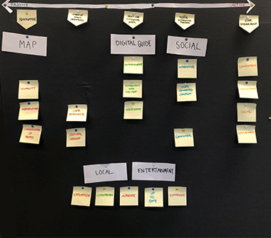
Mindmap of functions
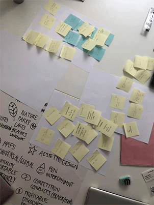
When all the groups came back from the fieldwork with gathered information, we started sharing and discussing our insights. We analyzed the data and sorted out all the functions that we found relevant to a city guide app.
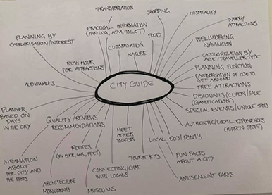
After laying out all the ideas, we started sorting them out based on their functionalities and how essential they were for the app. We categorized them in several groups: map, interactive functions, extra modules etc. Once we sorted all ideas out, we went on by discussing each one, how could it be developed and what would it work well together with.
Innovation tracks
Once we gathered all the data, we sorted out the essential factors and we started formulating different concepts. We created 5 different concepts, all of which represented a solution to the case that introduces a different innovation path. We did a lot of testing and research of the field in order to come up with concepts that differentiate form the ones that are already on the market. The tracks varied depending on how applicable to the different kinds of tourists they were and how active the user was while using them.

Track 1: A Map App
A digitized version of the ordinary physical map that many people prefer using. The idea was to create a functional, practical and informative app that could generate routes and be applicable to many different target groups.
Track 2: The Local App
This concept took into consideration exploring the local: finding the ‘hidden gems’ in a city and getting to know a different site, unexplored by most tourists. The visitors could get some cultural inside and taste the authentic, with the option to get in touch with a local citizen who could guide them during their journey.
Track 3: The Digital Guide
Imagine: instead of having an experienced guide who takes you through the city, you could just open an app and have one there! An interactive application that contains all kind of information regarding attractions, restaurants and entertainment, stored nicely into categories. The app could create a route for the based on preferences and lead him or her through the journey around the city.
Track 4: The Social Guide
An interactive app that would keep the user up to date on current events and the social aspect of each city. In addition to that, the users could generate content and enrich the app: reviews, recommendations and popular routes, all created from users for users. A concept that could transform any trip into a social event.
Track 5: The Entertaining App
This concept converted each city visit into a game – exploration of new place, combined with fun and a bit of competition. Each location that the users explore could unlock new attractions in the vicinity and bring prizes like for example discount coupons or bonus points and hidden tips
Once we had all the innovation track, we met with our case partner and presented all of them with a detailed explanation. Then, together with Combine, we had a discussion in which they picked out the functionalities they like the most out of each concepts and we formed an idea about the final concept that would be a combination of different functionalities, representing an innovative app. They wanted a concept for an entertaining app that could help the tourists to explore the local hidden gems and turn every city walk into an adventure.
Sketches of the concept
Once we had all the key functionalities of the app picked out, we concentrated on combining them all in a way so that we create a sustainable and entertaining app. In order to understand all of them and get in depth, we visualized them by sketching them out and creating short videos. Each video represents a key functionality of the app. While creating the videos, we generated some more ideas on how to improve the concept and we saw what works out well.
Expanding Map
In order to turn the traditional city walk into an adventure, we introduced the function of a map that could expand based on the location and the preferences of the user. In this way, once the tourists reach a certain location, they could unlock similar attractions in the vicinity.
Categorization
During our research process, we observed that many people find the similarity and the lack of personalization in most maps problematic. Therefore we explored the option of creating a customized profile for each user, depending on their personal preferences, age and transportation means.
Discount
In order to turn every city walk into an adventure, we turned the trip into a game in which each visited location brings the user bonus points. When a certain amount is collected, the user could win a prize such as a discount coupon for a local coffee place. In this way local businesses could get involved in the process and be promoted, while the tourists could explore the local cuisine and get a taste of the city.
Local attractions
During our research we found out that most maps introduce to the user mostly the main attractions in each city and many tourists lack the opportunity to see the local ‘hidden gems’. Therefore we came up with a concept for implementing a function that shows the unexplored areas of the cities that could be interesting to the visitors.